This is the link to the exam board website on here are past papers and their mark schemes. The only thing not on here are the OS maps. But it should help you with your revision.
http://www.ocr.org.uk/qualifications/type/l_gcse/geography/c/documents/
Good Luck,
Love
Mrs C xxxx
Friday 28 May 2010
Friday 23 April 2010
Sunday 18 April 2010
Montserrat Volcano LEDC Cast Study
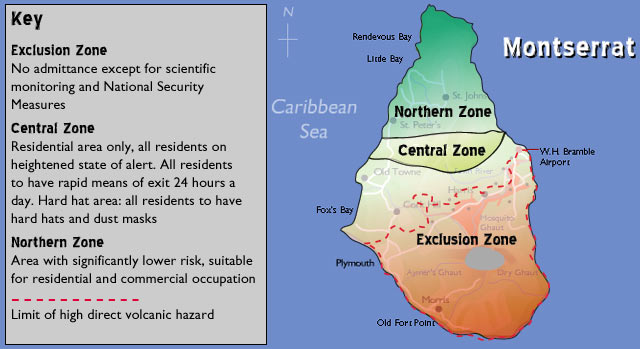
Primary Effects
When the volcano in Montserrat erupted it destroyed most south side of the island were most of the people lived. This meant that most of the island had to evacuated.
Secondary Effects
Secondary effects are effects of the volcano after the eruption. One of the secondary effects was loss of homes because pyroclastic flows (fast-flowing currents of hot gas, ash and lava) which move at 100 miles per hour demolishing people’s houses. These flows are so hot they can incinerate any person who is unfortunate to be in the area. There was also lack of food for the inhabitants of Montserrat because of the eruption destroying people's farms & crops. The transport and normal services were disrupted because of the panic throughout the city and people knowing there could be another eruption any time soon. Finally another secondary effect of the eruption was loss of jobs because more & more people were leaving the island which obviously meant tourists wouldn't want to go to Montserrat knowing their lives are at risk.
Short-term responses
These are the immediate action taken during the eruption:
evacuation of airports and homes, emergency announcement, fire and ambulance service to those who could be reached, helicopter search for survivors, emergency food and medical supply and animal evacuation.
Long-term responses
These are the action people took after the eruption:
Rebuild homes and airports, Government fund a programme to take action to develop the north of the island, Health, education and communication investments, Emergency service investment and upgrading the hospitals, Emergency housing, medical supplies.
Friday 16 April 2010
Kashmir Earthquake LEDC case study

When: 8.40am 8th October 2005
Where: Kashmir
Magnitude: 7.6
Focus: 26km
Epicentre: Muzzafarabad
Lasted: 60 seconds
Why: Collision plate boundary - Indo Australian Plate and Eurasian Plate. The two plates have the same densities and are both continental crust, therefore when they meet there is NO subduction, the two plates buckle upwards to form fold mountains, in this case the Himalayas. Pressure builds up in the crust that is released suddenly, this is the earthquake.
Primary Effects
Buildings collapsed, windows shattered, roads cracked and bridges collapsed.
79 000 people were killed
100 000 injured
3.3 million were made homeless
Massive landslides occurred burying villages and cutting remote areas off completely.
The time of day meant that lots of children had just started their school day, many schools collapsed in the quake killing thousands of school children.

Secondary Effects
Fires broke out as gas pipes cracked.
Diseases such as cholera and typhoid spread quickly from dirty water and dead bodies.
The cold meant people caught pneunomia.
People died as a result of the cold because they only had tents to live in.
Long Term Effects
Rural areas were less badly effected as the crops and animals mainly survived.
Urban areas needed to be rebuilt, this took time and cost a lot of money, many people lost their jobs.
Electricity lines were bought down and this hampered the rebuilding of the cities.
3.3 million people were initially made homeless, 1 million people were still homeless 1 year on from the disaster.
Cost of the damage was estimated to be $5 billion.
Short Term Responses
Local people rescued those trapped.
Indian Red Cross distributed 21,500 blankets, 300 kitchen sets and medical supplies.
The military deployed helicopters.
Peoples' injuries were prioritised using a numbering system, the lower the number, the sooner you got rescued.
The border between Pakistan and India was opened to allow emergency supplies in.
Rapid UK worked alongside Muslim Aid in helping to rescue the trapped.
Military hospitals were opened for civilian casualties,

Long Term Responses
The Red Cross established water supplies in Muzaffarabad.
The Army and Red Crescent (Aid organisation) build makeshift shelters.
Schools are being rebuilt.
Teachers are being trained to counsel the traumatised childtren.
Builiding laws have been tightened on public buildings so that they should withstand future quakes.
Monday 12 April 2010
Boscastle floods of 2004


The Boscastle floods were an example of flash flooding - an immediate response by a river to a period of intensive heavy rainfall. They occured on August 16th 2004 as a result of heavy rainfall that began at 12.30pm and dropped over 1.400 litres of water in just 2 hours. You can see the imapct the flooding had by looking at the images here and comparing the before and after shots of the bridge in the village centre. The catchment of the river Valency is small, (about 23 squared km) and includes the impermeable highland area of Bodmin moor. Steep sided valleys converge as they run down into Boscastle, creating a funnel effect, directing all the runoff into the main village. The ground was already saturated as a result of a very wet Auguast so the water flowed straight into the river Valency and made the water levels rise over 3m in less than 1 1/2 hours. This rise in water levels created a tide of water which flowed down through the village of Boscastle at speeds of up to 64km hour. Cars were swpt away, buildings destroyed and several peopel had to be rescued by the RAF.
Thursday 8 April 2010
Kobe Earthquake - MEDC Case Study

This is an excellent case study for an earthquake in an MEDC. There are links to videos that show how bad the quake was and some of the photos show the impact of this natural hazard.
When: 17th January 1995 at 5.46am
What: 7.2 earthquake occurred 20km south west of Kobe. Lasted for 20 seconds. The ground moved 18cm horizontally and 12cm vertically. This video shows footage from the actual earthquake:http://www.youtube.com/watch?v=yJPS4lokxtw
This earthquake occurred at a DESTRUCTIVE PLATE BOUNDARY Three crustal plates meet near to the coast of Japan. Close to Kobe, the denser oceanic Philippines Plate is being subducted beneath the lighter continental Eurasian Plate at a rate of about 10 centimetres per year. The Japanese island arc has been formed from the molten magma released by the melting Philippines Plate. Earthquakes are very common here and happen because of the friction resulting from the two plates colliding along this destructive margin. [In 1923, the Great Kanto Earthquake killed 140,000 people in this area.] The great destruction which resulted from the 1995 Kobe Earthquake was due to the shallow depth of the focus which was only about 16 kms. below the surface and the fact that the epicentre occurred close to a very heavily populated area. Seismic shockwaves travelled from Awaji Island (the epicentre) along the Nojima Fault to the cities of Kobe and Osaka.

What were the effects of the earthquake?
SHORT TERM
* 5477 people dead
* 35000 injuries
* 172000 homes collapsed
* 35 schools destroyed
* 3 hospitals destroyed
* 7500 further homes destroyed by the fires that started when the gas pipes fractured.
* Lack of water made fire fighting difficult
* 316000 evacuated from their homes
* shortage of blankets, food and water for the first 24 hours
* transport network devastated - five bridges collapsed, 130km section of Bullet train track destroyed. 1km section of Hanshin Expressway collapsed
* 196 berths at the port of Kobe were destroyed
* 1 million homes without gas, electricity and water.
* 285000 phone lines destroyed
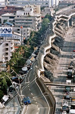
LONG TERM
* hundreds of businesses had to close down
* extra jobs created in the construction industries to rebuild the city
* damage was estimated to be 10 billion Yen
* Kobe's population fell by 33,000
Some videos that will help you.......
Southampton: site settlement factors and CBD redevelopment
Southampton: Site Settlement Factors:
We know that before the Romans there has been a settlement in Southampton; what factors make it such a good place to build a town:
· Proximity to the New Forest for building materials.
· Abundance of fresh water supply from 2 rivers.
· Abundance of natural food supply in the forest and the sea.
· Moderate to flat relief making building easy.
· Excellent natural port facilities, 2 major rivers and sheltered from the prevailing wind by the Isle of Wight.
· Easy communication links to the mainland of Europe.
 Modern Southampton
· During the war Southampton was the location for a number of German targets, including the Spitfire factory. It was therefore bombed heavily.
· In the Post war period until the 1970’s there was rapid period of council house and industrial rebuilding, often with little thought to the layout or the ambience.
· The main industry of the city has always been docks, and much of this also became quite heavily mechanised, meaning high unemployment.
· The city therefore experienced a negative multiplier effect, wherby people had little or no disposable income and therefore shops and services shut down. Also the CBD was relatively unpleasant with unsafe pedestrian access and high crime rates.
· Any shopping that did occur was generally in out of town shopping centres such as Hedge End and Whitely Village.
· During the early 1990’s the City council in order to tackle all the above problems began a process of redevelopment to breathe life back into the city.
· They realised for people to come back to the city, they needed shops and services people would use, as well as jobs for unemployed. They also recognized that much of the city was quite unattractive and needed rebuilding with more careful consideration.
The following video gives us an insight into the 'atmosphere' of a typical UK CBD in the mid 1980's, as well as some of the causes for it's decline:
What have Southampton City Council done to try and redevelop the CBD?
For a redevelopment project to be successful and sustainable (i.e last into the future) the city needs to have a prosperous core. Therefore as well as getting people back into the CBD for shopping and entertainment, there also needs to jobs that will last and opportunities for enterprise. This will then cause a 'positive multiplier effect' as if local people can make money and be successful they will spend their money on local services.
• Unlike a lot of modern regeneration projects Southampton's strategy has had to incorporate much of the light manufacturing and dock facilities that remain within the CBD fringes. With other similar cities (e.g. London, Bristol) the docks have been relocated further downstream to the estuary mouths and the former dock sites gentrified.
• Two of the most notable aspects of the regeneration has been the West Quay shopping centre which opened in 2000 and claims to be the largest town centre shopping mall in Europe. The success of this project was secured by ensuring favourable rates for high profile tenants such as John Lewis and Abercrombie and Fitch. As well as this on the adjacent West Quay retail park IKEA opened a branch in 2009, this has ensured a continual flow of visitors to the area from all over the central south and south west region.
• Redevelopment has also taken place in some of the old dock sites, most notable being the ocean village marina development where penthouse style apartments exist above wine-bar and upmarket eateries. Town Quay has also been redeveloped alongside Ocean Village in a similar manner, and each year plays host to the Southampton International Boat show.
• Former Brownfield industrial sites have been remediated to house leisure and entertainment complexes such as the Quays Swimming and Leisure centre, Leisure World Cinema and St. Mary’s Southampton FC Stadium.
p.s you will get all of this on a hard copy from your geog teacher, cheers Mr.B.
Subscribe to:
Posts (Atom)